Goole Rural District Guide 1971
Goole Rural District
Members of the Council
Councillors
The Parishes East of Dutch River
The Parishes West of Dutch River
Warp and Warping
Useful Information
Goole Rural District
Situated in the West Riding of Yorkshire, the Goole Rural District surrounds the town and port of Goole, and covers an area of 36,776 acres of virtually flat land, the highest point of which is only 50 feet above sea level.
The 15 parishes of the Rural District are Adlingfleet, Airmyn, Eastoft, Fockerby, Goole Fields, Gowdall, Haldenby, Hook, Ousefleet, Pollington, Rawcliffe, Reedness, Snaith and Cowick, Swinefleet and Whitgift.
The chief industry is agriculture and the soil tends to be sandy to the west of Goole and rich warp to the south and east.
The "Marshland Area" south and east of Goole and covering 16,635 acres was formerly a marsh which was gradually reclaimed by warping. This process leaves behind a rich warp soil suitable for growing root crops.
The protection of the land in this area dates back to 1315 but the artificial banks and drains are even earlier; later, in 1626, Cornelius Vermuyden, a Zeeland man, was employed to drain the marshes of the Don and Idle rivers.
Other industries include paper making, the extraction of moss peat, tar distilling and refining and distribution of wool fats.
Goole is the main market town although many people in the west of the district attend Selby or Pontefract markets. It is also the most inland port on the east coast, 50 miles from the sea with waterways leading inland to the towns and coalfields of West and South Yorkshire. Following the opening of the Knottingley-Goole canal, Goole was created a port of foreign trade in 1826.
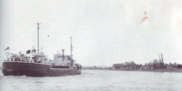
From the parishes on the south bank of the Ouse a view of the river towards the Port of Goole may be obtained. From these points shipping may be seen carrying their exports of coal and coke, pitch, slag, machinery, iron and steel manufactures, oil, spirit and textiles together with imports of grain, flour, food and provisions, iron and steel ores, timber, chemicals, and chemical fertilizers and raw wool.
Members of the Council
Chairman
T.C. Kettlewell, J.P. "Little Orchard", Hook.
Vice-Chairman
E. Cottam, Council Houses, Reedness.
Councillors
Adlingfleet:
N.V.K. Dodsworth, Adlingfleet Grange, Swinefleet.
Airmyn:
E. Heppenstall, The Courts, Airmyn.
Eastoft:
Mrs. Susan Coulman, The Hall, Eastoft.
Goole Fields:
H. Hodgson, The Barracks, Goole Fields.
Gowdall:
J. Dean, Grange Farm, Gowdall.
Haldenby:
T.W. Knapton, "The Old Vicarage", Adlingfleet.
Hook:
T.C. Kettlewell, J.P., "Little Orchard", Hook.
Ousefleet:
F.C. James, Ousefleet.
Pollington:
A.H. Asquith, Fir Tree Farm, Pollington.
Rawcliffe:
B.W. Beaumont, "Mytholme", Rawcliffe Bridge.
H. Mason, Gan-da-Ril, The Green, Rawcliffe.
Reedness:
E. Cottam, Council Houses, Reedness.
Snaith & Cowick:
Mrs. M.M. McDiarmid, "Clunie", South Parkway, Snaith.
H. Haynes, 14 Little London, West Cowick.
Swinefleet:
S. Woolas, Prospect Farm, Swinefleet.
Whitgift:
J.B. Moore, Angel Inn, Reedness.
The Council meet monthly on Wednesdays at 10:30am at the Council Offices, 149 Boothferry Road, Goole.
Clerk and Chief Finance Officer:
R. Bullock, A.C.I.S.
Deputy Clerk:
R. Simpson
Surveyor and Public Health Inspector:
J.A. Potts, F.I.P.H.E., M.A.P.H.I.
Medical Officer of Health:
Muriel J. Lowe, M.B., B.S., M.R.C.S., L.R.C.P., D.P.H., D.C.H.
Offices:
149 Boothferry Road, Goole. Tel. Goole 2313/4.
The Parishes East of Dutch River
Goole Fields
This parish, just south of Goole itself, has no actual village but a cluster of houses known as "The Barracks" by the inhabitants. There are no shops in the parish but those at Goole are within easy reach. The civil parish is in the ecclesiastical parish of Goole.
Agriculture is the main industry, although many local men find work in Goole itself.
Swinefleet
Three miles east of Goole on the banks of the River Ouse, Swinefleet is believed to have been an ancient settlement of King Sweyn, who is thought to have camped here during 1013.
St. Margaret's church in Church Lane is an ancient brick-built church with a bell turret. The village also has a Methodist church and a church hall built over 50 years ago. There is a primary school in the village but older children go to school in Goole.
Crops of wheat, corn, oats, barley, beet and potatoes are grown here.
Reedness and Whitgift
One and a half miles east of Swinefleet, Reedness is a pleasantly situated village adjoining the village of Whitgift.
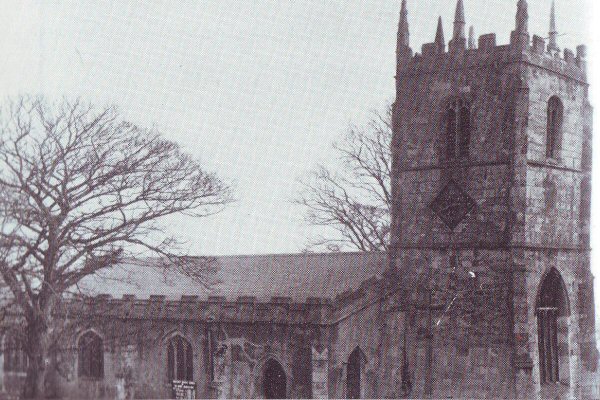
The church of St. Mary Magdalen, Whitgift, is Early English, erected in 1304, and serves the parishes of Reedness, Whitgift and Ousefleet.
Whitgift Hall is a handsome Elizabethan style hall and is situated about half a mile from the village.
The village was originally owned by Selby Abbey and the monks, wishing to protect their lands, built a sea wall between the years 1127 and 1137. Here also is Whitgift Clough which is believed to be the earliest sluice gate in the country.
Ousefleet show in August is held in Reedness.
Ousefleet
The parish of Ousefieet lies at the confluence of the Ouse and Trent rivers about seven miles from Goole and is the most easterly point in the West Riding.
Hall Garth was the site of an ancient manor house and there are still some foundations and earthworks to be seen. The manor was the ancestral home of the Usflet family who also had a chantry chapel at Ousefleet. One of this family, Sir Gerald de Usflet, was reputed to have fought at the Battle of Agincourt.
Adlingfleet
Adlingfleet, one of the larger parishes, south-east of Goole, has a long and remarkable history for it dates back to the time when Bishop Petwin was consecrated in the Saxon church which stood there in A.D. 763.
In the Domesday Book the village had a church with a priest and a mill, remains of which have been found near the church. During the 13th century it had grown to become one of the five richest villages in the country controlled by nationally known clergy and landowners. One such man was Bogo de Clare, the rector who presented the Queen of France with an ivory chariot. In A.D. 1250 John le Franceys was respon-sible for most of the building of the present church. A little Norman work still exists but the Early English clustered columns and the nave are his work. During the Middle Ages pilgrims flocked to the church as it was believed to contain a fragment of the True Cross.
In A.D. 1307 the church lost its fortunes due to a quarrel between the rectors and Selby Abbey so that only the vicarage continued to be maintained by the Abbey.
The three church bells were donated by the Rev. William Brown and much of the restoration work was sponsored by the Rev. Isaac Tyson who also wrote some most interesting notes of the church history in the "Gentleman's Magazine".
Of the monumental tombs in the church that of Margaret Egmonton A.D. 1370 is the earliest. A small brass memorial to Christopher Egmonton 1569, the last of that line, may be seen on the north aisle wall amongst the tombs of the Skerne-Ramsden family who took over the Egmonton lands.
Another fine tomb is that of Mrs. Mary Ramsden by the sculptor Nukey. In 1745 she left large estates to St. Catharine's College, Cambridge. In accordance with her will a sermon is preached here on 5th November.
Other antiquities include the ancient Quaker cemetery near Manor Farm and a curious stone building near Church Farm, believed to have been the tithe barn of John le Franceys, an exchequer baron of the king, built of stone taken from a disused church in Whitgift.
Much of the parish was marshland but was excellent hunting and shooting country. Since Vermuyden's diversion of the Don and warping schemes of the 18th and 19th century the land is now used for agriculture, although wild fowl still abound.
Fockerby
This parish of rich warp land, south of Adlingfleet, is entirely agricultural and forms the southern boundary of the Rural District. The village was the site of Fockerby Grammar School connected with St. Catherine's College, Cambridge for Mrs. Mary Ramsden endowed it with six fellowships and 12 scholarships. The school is now closed.
Haldenby
This parish south-west of Fockerby comprises a number of scattered farms which are highly cultivated and produce wheat and potatoes. The land was reclaimed from the marshes by the warping process which left a rich silt soil behind it.
Eastoft
Eastoft on the King's Causeway road is a divided village, the larger part is in Lincolnshire but the school, church and houses are all in Yorkshire.
The county boundary runs down the bed of the old River Don. The land has been reclaimed through warping. Arable farming occupies the villagers, wheat and potatoes being the main crops.
The Parishes West of Dutch River
Hook
On the banks of the River Ouse and about two miles north of Goole is the parish of Hook. The parish church of St. Mary is a small Early English church with a bell turret. The main street runs parallel to the river and modern residences and the old cottages of the village stand side by side.
Airmyn
The parish of Airmyn, one of the most delightful in the area, is 2½ miles north west of Goole. The High Street is most attractive with red-tiled cottages on one side and tree-lined river bank on the other.
St. David's church, High Street consists of a nave and bell turret with two bells and it also displays a fine stained glass window.
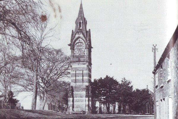
At the northern end of the village is an elegant stone clock tower, erected by the tenants in 1865 as a testimonial to George Percy, Earl of Beverley. In 1950 Brigadier Heber Percy gave the clock and the land on which it stands to the Rural District Council.
There is an industrial estate stretching from the Goole Borough boundary into the Parish of Airmyn. More land is being made available to meet the steady demand for industrial sites. Already on the estate, within the Goole Rural area are established a canning factory, a concrete works, a factory producing fibre glass, a lager distribution centre, a container packing factory and an egg packing station.
There is still space for further development and enquiries are always welcomed.

Rawcliffe is the most populous village in the Rural District and really comprises two villages - Rawcliffe and Rawcliffe Bridge - which are 1½ miles apart.
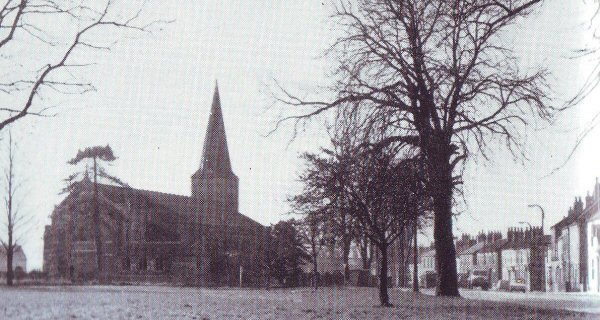
The old village of Rawcliffe is pleasantly situated beside the River Aire and houses surround the village green which is bordered with chestnut trees and seats and serves as an excellent playground for children.
The church of St. James rebuilt in 1842 is in the Early English style and consists of chancel, nave, aisles and a tower surmounted by a spire with bells and a clock. In the churchyard are the graves of "Jemmy" Hurst's parents.
Jemmy was a local eccentric whose favourite sports were hunting on his pet bull and shooting with his dog and pig. He was summoned to the court of King George Ill and when asked what he thought of London replied that he liked it very well but thought all the people to be fools.
Rawcliffe Hall Hospital is a large country house; one wing dates from 1660 and another was built in 1897 following a disastrous fire.
The village originally belonged to the Abbey of Selby and the Abbot resided at the Manor house for parts of the year.
The Village Hall was erected in 1929 through public donations. A new home for old people, Parklands, was opened about five years ago. There is room for 35 beds with pleasant dining and sitting rooms. A school for handicapped children was built by the West Riding County Council about six years ago.
Rawcliffe Bridge is the main industrial area of the Rural District about three miles from Goole along the Dutch River and six miles by road from Goole. The following industries have factory sites at Rawcliffe Bridge. Lin Pac Containers Ltd.; Croda Limited; and Fisons Peat Works. There are excellent transport facilities by road, rail and river.
Snaith and Cowick
Eight miles west of Goole lies the parish of Snaith and Cowick, comprising the villages of East and West Cowick and Snaith.
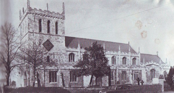
Snaith is an ancient chartered market town. The main feature of the town is the priory church of St. Laurence. The main structure, including the tower, date from about 1250 although there is some earlier work. The nave, chancel and chapels stand on the original foundations but date from about 1400 and the battlements and pinnacles were added in 1590. Of special interest are: the statue of Viscount Downe, 1837 by Chantry; the rood loft spiral staircase and the Easter Sepulchre. The parish registers date from 1537.
Other interesting features of the parish are Snaith Hall, built in the last century; Downe Arms Hotel, an old coaching station; the Old Grammar School founded in 1624 (now the church hall); three bede-houses for men and six almshouses for women.
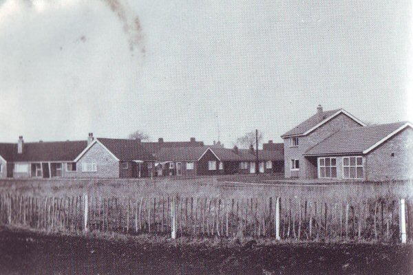
Twelve new bungalows have been built for old people making 27 in all, and this scheme includes a community centre and warden's house.
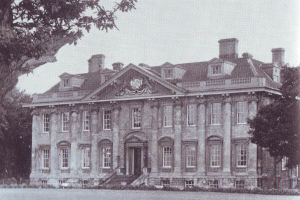
Cowick Hall is of great architectural interest and was formerly the home of Viscount Downe. The mansion is regarded as an excellent example of Renaissance architecture, and is thought to have been built about 1752. Cowick park was once a Norse settlement situated at the mouth of the Don. During the reign of the Plantagenet Kings there was a hunting lodge here, where they spent a lot of their time.
Gowdall
The parish of Gowdall lies one mile west of Snaith, the population being engaged in agriculture otherwise in work outside the area.
The village has a Church of England mission church and a Methodist chapel. The children from the parish go to school in Snaith where evening classes are also held during the winter.
Pollington
Two miles west of Snaith is Pollington, another straggling agricultural village lying on the highest ground in the Rural District, although even here the land does not rise above the 50-foot contour line.
Here are situated the Waterworks of the Pontefract, Goole and Selby Water Board, water being obtained from boreholes in the red sandstone.
Pollington was originally a settlement of an Anglian family. In an old Poll Tax record of 1378 the village was assessed at £1 17s. 8d. which was contributed by 180 persons. At that time there were two sworn officers and a sworn constable.
An interesting find was that of a stone coffin weighing at least two tons and containing the skeleton of a woman, preserved in gypsum, who had died in the 4th or 5th century.
Warp and Warping
Contributed by Robert Plewes Formerly Surveyor - Goole Rural District Council
The waters of the rivers which intersect or form part of the boundaries of the Goole Rural District - the Dutch River, Don, Aire, Trent - hold in suspension what is locally known as warp.
This is of a light chocolate colour containing shining flakes of mica, and of a peculiar soft silky feel which it may be readily recognised. An analysis shows that three parts out of four of it consists of sand, mica, and other matters insoluble in acid; lime and magnesia together constitute about 6 per cent and alumina an equal proportion. The appearance and physical characters of the warp are very different from those of the sediments deposited by the rivers in the non-tidal portion of their course, that of the Ouse being a coarse brown sandy loam and of the Aire, a black loose woolly-looking earth. The foregoing explanation is taken from a paper given by Dr. Parsons, Medical Officer of Health, 1878.
From time to time the experts have differed in their views as to the source of this sediment or warp. Is it brought down the rivers from the north, west and the south, or does it reach the estuary from the North Sea? Mr. T. Sheppard's book of 1912 gives a detailed account of his views, which are that both sources contribute.
If the rivers Ouse and Trent be examined at ebb tide when the normal amount of water is flowing down it will be seen that the waters are comparatively clear and, though a fairly large amount of material may be brought down from the higher reaches of the rivers, in solution, very little appears to be coming down in suspension. It is a fact that when the tidal waters are flowing up stream, the water is much more muddy and coffee-coloured than when the waters of the rivers only are descending in their channels. Undoubtedly a quantity of detritus is carried along by the rivers, but this is mostly derived from the high ground near their sources, and the bulk of it, in all probability, goes towards building up the alluvial flats so characteristic of the Ouse and Trent.
The waters of the North Sea are continually washing particles of rock, sand and mud in a southerly direction and, slowly but surely, the material of the Yorkshire coast is travelling southward. The chalk boulders around Flamborough offer a good illustration. The cliffs of the Holderness coast are made up entirely of soft glacial clays. The boulder-clay cliffs are being quickly washed away and carried southward and the whole of the material must be gradually converted into gravel, sand or mud. A good deal of the material must be brought into the Humber at each tide and it would appear, therefore, that it is from the coast that much of the material in suspension is derived.
The process of warping is carried out by the admission of tidal water to an area which has already been embanked by permitting the warp (sand, mud etc.) contained in the water to settle, and by the discharge of the settled water back to the river. Two excellent examples of warping drains are to be seen in the Goole Rural area - Earnshaw's Warping Drain, which joins the Ouse on the Goole - Goole Fields boundary, and Swinefleet Warping Drain.
The amount of warp deposited at each admission of tide may be taken as averaging 1/8 inch. Warping may be carried out at any time of the year but the most favourable periods are during spring tides (the highest equinoctial tides in March and September being usually avoided) though ordinary tides can also usefully be admitted. Warping should be avoided when there is "fresh" in the river (since the percentage of solid material is thereby greatly reduced) and during stormy periods, as there is then danger of banks of the warping drain being damaged by wave action.
From a book of Robert Brown (1799) we learn that Mr. Richard Jennings of Airmyn was the first person who tried the experiment of warping about 1749. It was next attempted by a Mr. Farham of Rawcliffe, and also by Mr. Mould of Potter Grange.
In 1822 Mr. George Leather, Engineer, was requested to raise the level of some of the land near the mouth of the Dutch River by the process of warping which had been purchased for the making of the future Port of Goole.
But to Ralph Creyke, Jnr., Esq., we must look for his interesting account of the warping he carried out in the vicinity of Rawcliffe in 1821, whereby he was awarded the Large Gold Medal of the Society of Arts for his papers giving full details for warping 429 acres of Peat Moss. One of the conditions of the award was "for an account of a method superior to any hitherto practised of improving land lying waste". Mr. Creyke having ascertained that a tract of about 1,600 acres of peat moss in the neighbourhood of Rawcliffe, which produced absolutely no rent, was at a sufficiently low level to be warped, resolved to subject the whole to this mode of rendering it productive.
Mr. Creyke writes "In August 1821 a sluice, with two openings to 16 feet each and 19 feet high from the sole to the crown of the arch, with substantial folding doors, was built and opened, and at the same time a main drain was cut extending from it two miles and a half. Its dimensions were 30 feet wide at the bottom and 90 feet wide at the surface of the land, and the banks were raised upon the land to the height of 16 feet, where the sluice is built. In the first year 429 acres of waste land were embanked in order to be improved, and on it was deposited in the course of that year, a fine alluvial soil of the average depth of near three feet. This allotment was sown with oats and seeds in 1823 and the seeds were either mown or depastured in 1824. It is now sown with wheat, which looks very prominent and luxuriant. No part of this allotment of 429 acres yielded any rent previous to this improvement, and now no part of it is let for less than 35 shillings per acre. The expense is £21 per acre. According to the usual practice of warping the tides are only admitted during the months of August, September and October. In mine they are admitted the year round.
"The sluice was not more than five feet wide, mine has two openings of 16 feet wide. The main drain was only 12 feet wide, mine is 90 feet wide. Not more than 14 acres were embanked in one piece, I have enclosed 500 acres in one compartment. Formerly not more than one and a half feet of deposit was obtained, I have got from three to four feet in the same time upon the increased quantity of land."
The last warping operation carried out in this locality was at Blacktoft, from Blacktoft Warping Drain in the year 1948.
The above article, besides its intrinsic interest as a part of the history of the district, clarifies the use of the terms "warping" and "warp land" which occur in the descriptions of the individual parishes.
It is interesting to note that the moss peat, once such a problem to agriculture, is now itself a profitable "export" of the area. Messrs. Fisons, the agricultural and horticultural chemists, have established a modern enterprise for its extraction, grading, packaging and sale.
Useful Information
Area:
36,776 acres.
Population:
9120
Rates in the £:
73p
Rateable Value:
£254,462
Accommodation:
North Eastern Hotel, Goole; Station Hotel, Goole.
Early Closing Day:
Goole-Thursdays.
Market Days:
Goole-Wednesdays, Fridays and Saturdays.
Bus Services:
Lincolnshire Road Car Co. Ltd., run service routes between Goole and the parishes of Hook, Swinefleet and Ousefleet. The West Riding Automobile Co. Ltd. operate a daily service between Goole, Snaith and Pollington.
Garages:
W. Clayton & Sons Ltd., Gilberdyke; Glew's Boothferry Garage, Goole; Kenning Motor Group, Goole; E. l. Hudson, Rawcliffe; Station Garage (Snaith) Ltd., Snaith, Airmyn Garage Ltd., Airmyn.
Schools:
Primary Schools: Airmyn, Eastoft, Goole (6), Hook, Pollington, Rawcliffe (2), Reedness (2), Snaith, Swinefleet, Whitgift.
Secondary Schools: Goole, Snaith;
Grammar School: Goole.
Libraries:
Public Library, Carlisle Street, Goole; Rawcliffe Village Hall; Snaith Primary School, Market Place, Snaith; Reedness Primary School; Airmyn Primary School; Hook Primary School; Swinefleet Primary School.
Hospitals:
St. John's Hospital; Bartholomew Hospital; Westfield Hospital; Goole Maternity Hospital.
Clinics:
Prospect House, Swinefleet; Rose Cottage, Snaith.
Newspapers:
The Goole Times series comprising the Goole Times, Selby Express, Howdenshire Gazette.